The
main objective of this online textbook is
to introduce students to the exciting field
of knowledge known as physical
geography. Physical geography is a discipline
that is part of a much larger area of understanding
called geography.
Most individuals define geography as a field
of study that deals with maps.
This definition is only partially correct. A
better definition of geography may be the
study of natural and human constructed phenomena
relative to a spatial dimension.
The discipline of geography
has a history that stretches over many centuries. Over this
time period, the study of geography has evolved and developed
into an important form of human scholarship. Examining the
historical evolution of geography as a discipline provides
some important insights concerning its character and methodology.
These insights are also helpful in gaining a better understanding
of the nature of physical geography.
History of Geography
and Physical Geography
Some of the first truly geographical
studies occurred more than four thousand years ago. The main
purpose of these early investigations was to map features
and places observed as explorers traveled to new lands. At
this time, Chinese, Egyptian, and Phoenician civilizations
were beginning to explore the places and spaces within and
outside their homelands. The earliest evidence of such explorations
comes from the archaeological discovery of a Babylonian clay
tablet map that dates back to 2300 BC.
The
early Greeks were the first civilization
to practice a form of geography that was
more than mere map making or cartography.
Greek philosophers and scientist were also interested in
learning about spatial nature of human and physical features
found on the Earth. One of the first Greek geographers was Herodotus (circa
484 - 425 BC). Herodotus wrote a number of volumes
that described the human and physical geography
of the various regions of the Persian Empire.
The ancient Greeks were also
interested in the form, size, and geometry of the Earth. Aristotle (circa
384 - 322 BC) hypothesized and scientifically demonstrated
that the Earth had a spherical shape. Evidence for this idea
came from observations of lunar eclipses. Lunar eclipses
occur when the Earth casts its circular shadow on to the
moon's surface. The first individual to accurately calculate
the circumference of the Earth was the Greek geographer Eratosthenes (circa
276 - 194 BC). Eratosthenes calculated the equatorial circumference
to be 40,233 kilometers using simple geometric relationships.
This primitive calculation was unusually accurate. Measurements
of the Earth using modern satellite technology have computed
the circumference to be 40,072 kilometers.
Most
of the Greek accomplishments in geography
were passed on to the Romans. Roman military
commanders and administrators used this information
to guide the expansion of their Empire. The
Romans also made several important additions
to geographical knowledge. Strabo (circa
64 BC - 20 AD) wrote a 17 volume series called "Geographia".
Strabo claimed to have traveled widely and recorded
what he had seen and experienced from a geographical
perspective.
In his series of books, Strabo describes the
cultural geographies of the various societies
of people found from Britain to
as far east as India, and south to Ethiopia and
as far north as Iceland. Strabo also suggested
a definition of geography
that is quite complementary to the way many human
geographers define their discipline today. This
definition suggests that
the aim of geography was to "describe
the known parts of the inhabited world ... to
write the assessment of the countries of the world [and]
to treat the differences between countries".
During the second century AD, Ptolemy (circa
100 - 178 AD) made a number of important contributions
to geography. Ptolemy's publication Geographike
hyphegesis or "Guide
to Geography" compiled and summarize much
of the Greek and Roman geographic information
accumulated at that
time. Some of his other important contributions
include the creation of three different methods
for projecting the Earth's
surface on a map, the calculation of coordinate
locations for some eight thousand places on the
Earth, and development
of the concepts of geographical latitude and longitude (Figure
1a-1).
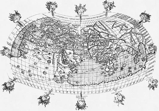
| Figure 1a-1: This
early map of the world was constructed using map making
techniques developed by Ptolemy. Note that the map is
organized with crisscrossing lines of latitude and longitude. |
Little
academic progress in geography occurred after
the Roman period. For the most part, the
Middle Ages (5th to 13th centuries AD) were
a time of intellectual stagnation. In Europe,
the Vikings of Scandinavia were the only
group of people carrying out active exploration
of new lands. In the Middle East, Arab academics
began translating the works of Greek and
Roman geographers starting in the 8th century
and began exploring southwestern Asia and
Africa. Some of the important intellectuals
in Arab geography were Al-Idrisi, Ibn Battutah,
and Ibn Khaldun. Al-Idrisi is best known
for his skill at making maps and for his
work of descriptive geography Kitab nuzhat al-mushtaq
fi ikhtiraq al-afaq or "The
Pleasure Excursion of One Who Is Eager to Traverse the Regions
of the World". Ibn Battutah and Ibn Khaldun are
well known for writing about their extensive travels of North
Africa and the Middle East.
During the Renaissance (1400
to 1600 AD) numerous journeys of geographical
exploration were commissioned by a variety
of nation states in Europe. Most of these voyages
were financed because of the potential commercial
returns from resource exploitation. The voyages
also provided an opportunity for scientific
investigation and discovery. These voyages
also added many significant contributions to
geographic knowledge (Figure 1a-2).
Important explorers of this period include Christopher
Columbus, Vasco
da Gama, Ferdinand
Magellan, Jacques
Cartier, Sir
Martin Frobisher, Sir
Francis Drake, John and Sebastian
Cabot, and John
Davis. Also during the Renaissance, Martin
Behaim created a spherical globe depicting
the Earth in its true three-dimensional form
in 1492.
Behaim's invention was a significant advance over two-dimensional maps because
it created a more realistic depiction of the Earth's shape and surface configuration.
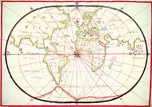
| Figure 1a-2: This
map was constructed by Oliva in 1560. It describes the
known world at this time and suggests that North America
is part of Asia. Further exploration of the world would
soon reject this idea. |
In the 17th century, Bernhardus
Varenius (1622-1650) published an important geographic
reference titled Geographia
generalis (General
Geography: 1650). In this volume, Varenius
used direct observations and primary measurements
to present some new ideas concerning geographic
knowledge. This work continued to be a standard
geographic reference for about a 100 years.
Varenius also suggested that the discipline
of geography could be subdivided into three
distinct branches. The first branch examines
the form and dimensions of the Earth. The
second sub-discipline deals with tides, climatic
variations over time and space, and other
variables that are influenced by the cyclical
movements of the Sun and moon. Together these
two branches form the early beginning of
what we collectively now call physical geography.
The last branch of geography examined distinct
regions on the Earth using comparative cultural
studies. Today, this area of knowledge is
called cultural geography.
During the 18th century, the
German philosopher Immanuel
Kant (1724-1804) proposed that human
knowledge could be organized in three different
ways. One way of organizing knowledge was to
classify its facts according to the type of objects
studied. Accordingly, zoology studies animals,
botany examines plants, and geology involves
the investigation of rocks. The second way one
can study things is according to a temporal dimension.
This field of knowledge is of course called history.
The last method of organizing knowledge involves
understanding facts relative to spatial relationships.
This field of knowledge is commonly known as
geography. Kant also divided geography into a
number of sub-disciplines. He recognized the
following six branches: Physical, mathematical,
moral, political, commercial, and theological
geography.
Geographic
knowledge saw strong growth in Europe and
the United States in the 1800s. This period
also saw the emergence of a number of societies
interested in geographic issues. In Germany, Alexander
von Humboldt, Carl
Ritter, and Fredrich
Ratzel made substantial contributions
to human and physical geography. Humboldt's
publication Kosmos (1844)
examines the geology and physical geography
of the Earth. This work is considered by
many academics to be a milestone contribution
to geographic scholarship. Late in the 19th
Century, Ratzel theorized that the distribution
and culture of the Earth's various human
populations was strongly influenced by the
natural environment. The French geographer Paul
Vidal de la Blanche opposed this
revolutionary idea. Instead, he suggested
that human beings were a dominant force shaping
the form of the environment. The idea that
humans were modifying the physical environment
was also prevalent in the United States.
In 1847, George
Perkins Marsh gave an address to
the Agricultural Society of Rutland County,
Vermont. The subject of this speech
was that human activity was having a destructive
impact on land, especially through deforestation
and land conversion. This speech also became
the foundation for his book Man
and Nature or The Earth
as Modified by Human Action, first published in
1864. In this publication, Marsh warned of the ecological
consequences of the continued development of the American
frontier.
During
the first 50 years of the 1900s, many academics
in the field of geography extended the various
ideas presented in the previous century to
studies of small regions all over the world.
Most of these studies used descriptive field
methods to test research questions. Starting
in about 1950, geographic research experienced
a shift in methodology. Geographers began
adopting a more scientific approach that
relied on quantitative techniques. The quantitative
revolution was also associated with
a change in the way in which geographers studied the Earth
and its phenomena. Researchers now began investigating process
rather than mere description of the event of interest. Today,
the quantitative approach is becoming even more prevalent
due to advances in computer and software technologies.
In 1964, William Pattison published
an article in the Journal of Geography (1964,
63: 211-216) that suggested that modern Geography was now
composed of the following four academic traditions: