Before the late nineteenth century, time keeping was essentially a local phenomenon. Each town would set their clocks according to the motions of the Sun. Noon was defined as the time when the Sun reached its maximum altitude above the horizon. Cities and towns would assign a clockmaker to calibrate a town clock to these solar motions. This town clock would then represent "official" time and the citizens would set their watches and clocks accordingly.
The later half of the nineteenth century was time of increased movement of humans. In the United States and Canada, large numbers of people were moving west and settlements in these areas began expanding rapidly. To support these new settlements, railroads moved people and resources between the various cities and towns. However, because of the nature of how local time was kept, the railroads experience major problems in constructing timetables for the various stops. Timetables could only become more efficient if the towns and cities adopted some type of standard method of keeping time.
In 1878, Canadian Sir Sanford Fleming suggested a system of worldwide time zones that would simplify the keeping of time across the Earth. Fleming proposed that the globe be divided into 24 time zones, each 15 degrees of longitude in width. Since the world rotates once every 24 hours on its axis and there are 360 degrees of longitude, each hour of Earth rotation represents 15 degrees of longitude.
Railroad companies in Canada and the United States began using Fleming's time zones in 1883. In 1884, an International Prime Meridian Conference was held in Washington D.C. to adopt the standardize method of time keeping and determined the location of the Prime Meridian. Conference members agreed that the longitude of Greenwich, England would become zero degrees longitude and established the 24 time zones relative to the Prime Meridian. It was also proposed that the measurement of time on the Earth would be made relative to the astronomical measurements at the Royal Observatory at Greenwich. This time standard was called Greenwich Mean Time (GMT).
Today, many nations operate on variations of the time zones suggested by Sir Fleming. Figure 2c-1 describes the various time zones currently used on the Earth. In this system, time in the various zones is measured relative the Coordinated Universal Time (UTC) standard at the Prime Meridian. Coordinated Universal Time became the standard legal reference of time all over the world in 1972. UTC is determined from six primary atomic clocks that are coordinated by the International Bureau of Weights and Measures (BIPM) located in France. The numbers located at the bottom of Figure 2c-1 indicate how many hours each zone is earlier (negative sign) or later (positive sign) than the Coordinated Universal Time standard. Also note that national boundaries and political matters influence the shape of the time zone boundaries. For example, China uses a single time zone (eight hours ahead of Coordinated Universal Time) instead of five different time zones.
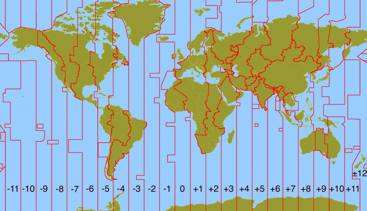
| Figure 2c-1: Modern standard times zones as measured relative to Coordinated Universal Time. The numbers located at the bottom indicate how many hours each zone is earlier (negative sign) or later (positive sign) than Coordinated Universal Time. Some nations (for example, Australia and India) have offset their time zones by half an hour. This situation is not shown on the illustration. |