Introduction and Brief History
The advent of cheap and powerful computers over the last few decades has allowed for the development of innovative software applications for the storage, analysis, and display of geographic data. Many of these applications belong to a group of software known as Geographic Information Systems (GIS). Many definitions have been proposed for what constitutes a GIS. Each of these definitions conforms to the particular task that is being performed. Instead of repeating each of these definitions, I would like to broadly define GIS according to what it does. Thus, the activities normally carried out on a GIS include:
-
The measurement of natural and human made phenomena and processes from a spatial perspective. These measurements emphasize three types of properties commonly associated with these types of systems: elements, attributes, and relationships.
-
The storage of measurements in digital form in a computer database. These measurements are often linked to features on a digital map. The features can be of three types: points, lines, or areas (polygons).
-
The analysis of collected measurements to produce more data and to discover new relationships by numerically manipulating and modeling different pieces of data.
-
The depiction of the measured or analyzed data in some type of display - maps, graphs, lists, or summary statistics.
The first computerized GIS began its life in 1964 as a project of the Rehabilitation and Development Agency Program within the government of Canada. The Canada Geographic Information System (CGIS) was designed to analyze Canada's national land inventory data to aid in the development of land for agriculture. The CGIS project was completed in 1971 and the software is still in use today. The CGIS project also involved a number of key innovations that have found their way into the feature set of many subsequent software developments.
From the mid-1960s to 1970s, developments in GIS were mainly occurring at government agencies and at universities. In 1964, Howard Fisher established the Harvard Lab for Computer Graphics where many of the industries early leaders studied. The Harvard Lab produced a number of mainframe GIS applications including: SYMAP (Synagraphic Mapping System),CALFORM, SYMVU, GRID, POLYVRT, and ODYSSEY. ODYSSEY was first modern vector GIS and many of its features would form the basis for future commercial applications. Automatic Mapping System was developed by the United States Central Intelligence Agency (CIA) in the late 1960s. This project then spawned the CIA's World Data Bank, a collection of coastlines, rivers, and political boundaries, and the CAM software package that created maps at different scales from this data. This development was one of the first systematic map databases. In 1969, Jack Dangermond, who studied at the Harvard Lab for Computer Graphics, co-founded Environmental Systems Research Institute (ESRI) with his wife Laura. ESRI would become in a few years the dominate force in the GIS marketplace and create ArcInfo and ArcView software. The first conference dealing with GIS took place in 1970 and was organized by Roger Tomlinson (key individual in the development of CGIS) and Duane Marble (professor at Northwestern University and early GIS innovator). Today, numerous conferences dealing with GIS run every year attracting thousands of attendants.
In the 1980s and 1990s, many GIS applications underwent substantial evolution in terms of features and analysis power. Many of these packages were being refined by private companies who could see the future commercial potential of this software. Some of the popular commercial applications launched during this period include: ArcInfo, ArcView, MapInfo, SPANS GIS, PAMAP GIS, INTERGRAPH, and SMALLWORLD. It was also during this period that many GIS applications moved from expensive minicomputer workstations to personal computer hardware.
Components of a GIS
A Geographic Information System combines computer cartography with a database management system. Figure 2f-1 describes some of the major components common to a GIS. This diagram suggests that a GIS consists of three subsystems: (1) an input system that allows for the collection of data to be used and analyzed for some purpose; (2) computer hardware and software systems that store the data, allow for data management and analysis, and can be used to display data manipulations on a computer monitor; (3) an output system that generates hard copy maps, images, and other types of output.
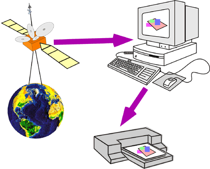
| Figure 2f-1: Three major components of a Geographic Information System. These components consist of input, computer hardware and software, and output subsystems. |
Two basic types of data are normally entered into a GIS. The first type of data consists of real world phenomena and features that have some kind of spatial dimension. Usually, these data elements are depicted mathematically in the GIS as either points, lines, or polygons that are referenced geographically (or geocoded) to some type of coordinate system. This type data is entered into the GIS by devices like scanners, digitizers, GPS, air photos, and satellite imagery. The other type of data is sometimes referred to as an attribute. Attributes are pieces of data that are connected or related to the points, lines, or polygons mapped in the GIS. This attribute data can be analyzed to determine patterns of importance. Attribute data is entered directly into a database where it is associated with element data.
The difference between element and attribute data can be illustrated in Figures 2f-2 and 2f-3. Figure 2f-2 shows the location of some of the earthquakes that have occurred in the last century. These plotted data points can be defined as elements because their main purpose is to describe the location of the earthquakes. For each of the earthquakes plotted on this map, the GIS also has data on their depth. These measurements can be defined as attribute data because they are connected to the plotted earthquake locations in Figure 2f-2. Figure 2f-3 shows the attribute earthquake depth organized into three categories: shallow; intermediate; and deep. This analysis indicates a possible relationship between earthquake depth and spatial location - deep earthquakes do not occur at the mid-oceanic ridges.
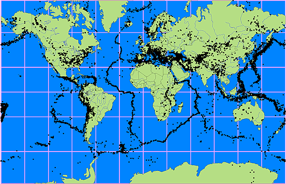
| Figure 2f-2: Distribution of earthquake events that have occurred over the last century. |
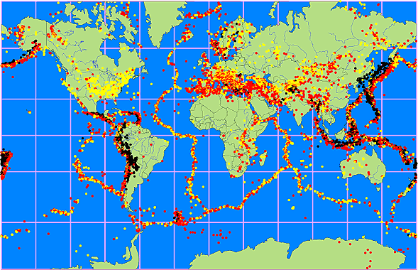
| Figure 2f-3: Earthquake events organized according to depth (yellow (shallow) = surface to 25 kilometers below the surface, red (intermediate) = 26 to 75 kilometers below the surface, and black (deep) = 76 to 660 kilometers below the surface). |
Within the GIS database a user can enter, analyze, and manipulate data that is associated with some spatial element in the real world. The cartographic software of the GIS enables one to display the geographic information at any scale or projection and as a variety of layers which can be turned on or off. Each layer would show some different aspect of a place on the Earth. These layers could show things like a road network, topography, vegetation cover, streams and water bodies, or the distribution of annual precipitation received. The output illustrated in Figure 2f-4 merges data layers for vegetation community type, glaciers and ice fields, and water bodies (streams, lakes, and ocean).
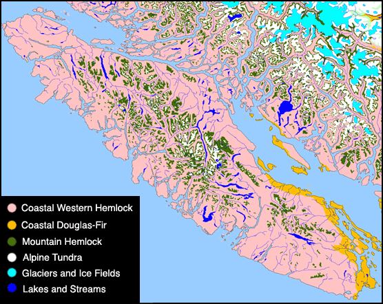
| Figure 2f-4: Graphic output from a GIS. This GIS contains information about the major plant communities, lakes and streams, and glaciers and ice fields found occupying the province of British Columbia, Canada. The output shows Vancouver Island and part of the British Columbia mainland. |