Surface Runoff
If the amount of water falling on the ground is greater than the infiltration rate of the surface, runoff or overland flow will occur. Runoff specifically refers to the water leaving an area of drainage and flowing across the land surface to points of lower elevation. It is not the water flowing beneath the surface of the ground. This type of water flow is called throughflow. Runoff involves the following events:
- Rainfall intensity exceeds the soil's infiltration rate.
- A thin water layer forms that begins to move because of the influence of slope and gravity.
- Flowing water accumulates in depressions.
- Depressions overflow and form small rills.
- Rills merge to form larger streams and rivers.
- Streams and rivers then flow into lakes or oceans.
On a global scale, runoff occurs because of the imbalance between evaporation and precipitation over the Earth's land and ocean surfaces. Oceans make up 71% of the Earth's surface and the solar radiation received here powers the global evaporation process. In fact, 86% of the Earth's evaporation occurs over the oceans, while only 14% occurs over land. Of the total amount of water evaporated into the atmosphere, precipitation returns only 79% to the oceans, and 21% to the land. Surface runoff sends 7% of the land based precipitation back to the ocean to balance the processes of evaporation and precipitation.
The distribution of runoff per continent shows some interesting patterns (see Table 8n-1). Areas having the most runoff are those with high rates of precipitation and low rates of evaporation.
| Table 8n-1: Continental runoff values. (Source: Lvovitch, M.L. 1972. World water balance, In: Symposium of World Water Balance. IASH-UNESCO. Report Number 92). |
| Continent |
Runoff Per Unit Area (mm per yr.) |
| Europe |
300 |
| Asia |
286 |
| Africa |
139 |
| North and Central America |
265 |
| South America |
445 |
| Australia, New Zealand and New Guinea |
218 |
| Antarctica and Greenland |
164 |
Streamflow and Stream Discharge
The term streamflow describes the process of water flowing in the organized channels of a stream or river. Stream discharge represents the volume of water passing through a river channel during a certain period of time. Stream discharge can be expressed mathematically with the following equation:
Q = W x D x V
where,
Q equals stream discharge usually measured in cubic meters per second, W equals channel width, D equals channel depth, and V equals velocity of flowing water.
Because of streamflow's potential hazard to humans many streams are gauged by mechanical recorders. These instruments record the stream's discharge on a hydrograph. The graph (Figure 8n-1) below illustrates a typical hydrograph and its measurement of discharge over time.
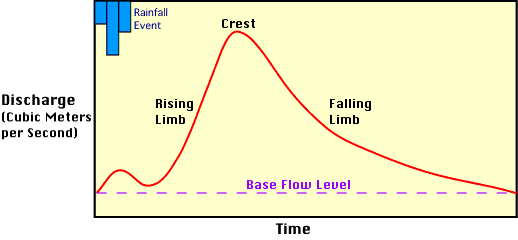
Figure 8n-1: Stream hydrograph.
From this graph we can observe the following things:
- A small blip caused by rain falling directly into the channel is the first evidence that stream discharge is changing because of the rainfall.
- A significant time interval occurs between the start of rain and the beginning of the main rise in discharge on the hydrograph. This lag occurs because of the time required for the precipitation that falls in the stream's basin to eventually reach the recording station. Usually, the larger the basin the greater the the time lag.
- The rapid movement of surface runoff into the stream's channels and subsequent flow causes the discharge to rise quickly.
- The falling limb of the hydrograph tends to be less steep that the rise. This flow represents the water added from distant tributaries and from throughflow that occurs in surface soils and sediments.
- After some time the hydrograph settles at a constant level known as base flow stage. Most of the base flow comes from groundwater flow which moves water into the stream channel very slowly.
Not all hydrographs are the same. Actually, the shape and magnitude of the hydrograph is controlled by two sets of factors:
Permanent Factors - slope of basin, soil structure, vegetation, channel density, etc.
Transient Factors - are those factors associated with precipitation input - size of storm, intensity, duration of rainfall, etc.