Thermal Circulations
As discussed earlier, winds blow because of differences in atmospheric pressure. Pressure gradients may develop on a local to a global scale because of differences in the heating and cooling of the Earth's surface. Heating and cooling cycles that develop daily or annually can create several common local or regional thermal wind systems. The basic circulation system that develops is described in the generic illustrations below.

Figure 7o-1: Cross-section of the atmosphere with uniform horizontal atmospheric pressure.
In this first diagram (Figure 7o-1), there is no horizontal temperature or pressure gradient and therefore no wind. Atmospheric pressure decreases with altitude as depicted by the drawn isobars (1000 to 980 millibars). In the second diagram (Figure 7o-2), the potential for solar heating is added which creates contrasting surface areas of temperature and atmospheric pressure. The area to the right receives more solar radiation and the air begins to warm from heat energy transferred from the ground through conduction and convection. The vertical distance between the isobars becomes greater as the air rises. To the far left, less radiation is received because of the presence of cloud, and this area becomes relatively cooler than the area to the right. In the upper atmosphere, a pressure gradient begins to form because of the rising air and upward spreading of the isobars. The air then begins to flow in the upper atmosphere from high pressure to low pressure.

Figure 7o-2: Development of air flow in the upper atmosphere because of surface heating.
Figure 7o-3 shows the full circulation system in action. Beneath the upper atmosphere high is a thermal low pressure center created from the heating of the ground surface. Below the upper atmosphere low is a thermal high created by the relatively cooler air temperatures and enhanced by the descending air from above. Surface air temperatures are cooler here because of the obstruction of shortwave radiation absorption at the Earth's surface by the cloud. At the surface, the wind blows from the high to the low pressure. Once at the low, the wind rises up to the upper air high pressure system because of thermal buoyancy and outflow in the upper atmosphere. From the upper high, the air then travels to the upper air low, and then back down to the surface high to complete the circulation cell. The circulation cell is a closed system that redistributes air in an equitable manner. It is driven by the greater heating of the surface air in the right of the diagram.
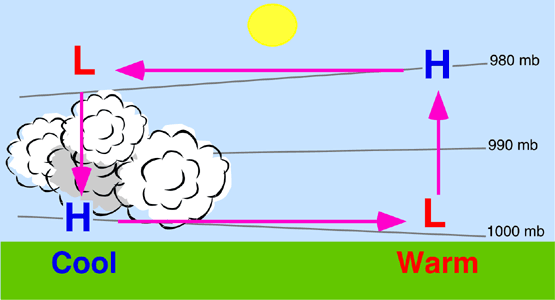
Figure 7o-3: Development of a closed atmospheric circulation cell because of surface heating.
Sea and Land Breezes
Sea and land breezes are types of thermal circulation systems that develop at the interface of land and ocean. At this interface, the dissimilar heating and cooling characteristics of land and water initiate the development of an atmospheric pressure gradient which causes the air in these areas to flow.
During the daytime land heats up much faster than water as it receives solar radiation from the Sun (Figure 7o-4). The warmer air over the land then begins to expand and rise forming a thermal low. At the same time, the air over the ocean becomes a cool high because of water's slower rate of heating. Air begins to flow as soon as there is a significant difference in air temperature and pressure across the land to sea gradient. The development of this pressure gradient causes the heavier cooler air over the ocean to move toward the land and to replace the air rising in the thermal low. This localized air flow system is called a sea breeze. Sea breeze usually begins in midmorning and reaches its maximum strength in the later afternoon when the greatest temperature and pressure contrasts exist. It dies down at sunset when air temperature and pressure once again become similar across the two surfaces.
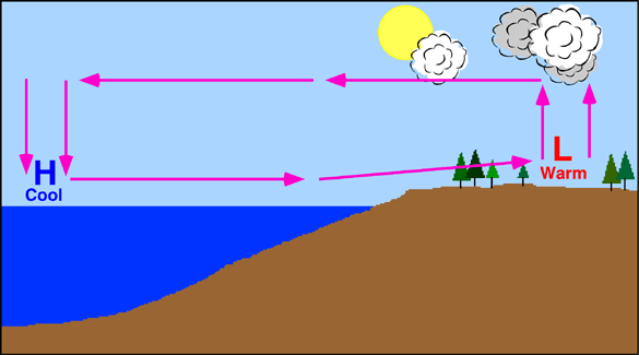
Figure 7o-4: Daytime development of sea breeze.
At sunset, the land surface stops receiving radiation from the Sun (Figure 7o-5). As night continues the land surface begins losing heat energy at a much faster rate than the water surface. After a few hours, air temperature and pressure contrasts begin to develop between the land and ocean surfaces. The land surface being cooler than the water becomes a thermal high pressure area. The ocean becomes a warm thermal low. Wind flow now moves from the land to the open ocean. This type of localized air flow is called a land breeze.
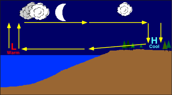
Figure 7o-5: Nighttime development of land breeze.
Mountain and Valley Breezes
Mountain and valley breezes are common in regions with great topographic relief (Figure 7o-6 and 7o-7). A valley breeze develops during the day as the Sun heats the land surface and air at the valley bottom and sides (Figure 7o-6). As the air heats it becomes less dense and buoyant and begins to flow gently up the valley sides. Vertical ascent of the air rising along the sides of the mountain is usually limited by the presence of a temperature inversion layer. When the ascending air currents encounter the inversion they are forced to move horizontally and then back down to the valley floor. This creates a self-contained circulation system. If conditions are right, the rising air can condense and form into cumuliform clouds.
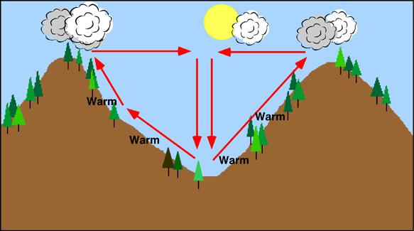
Figure 7o-6: Daytime development of valley breeze.
During the night, the air along the mountain slopes begins to cool quickly because of longwave radiation loss (Figure 7o-7). As the air cools, it becomes more dense and begins to flow downslope causing a mountain breeze. Convergence of the draining air occurs at the valley floor and forces the air to move vertically upward. The upward movement is usually limited by the presence of a temperature inversion which forces the air to begin moving horizontally. This horizontal movement completes the circulation cell system. In narrowing terrain, mountain winds can accelerate in speed because of the venturi effect. Such winds can attain speeds as high has 150 kilometers per hour.
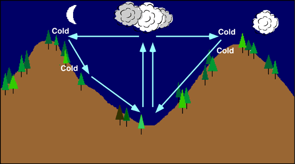
Figure 7o-7: Nightime development of mountain breeze.
Monsoon Winds
Monsoons are regional scale wind systems that predictably change direction with the passing of the seasons. Like land/sea breezes, these wind systems are created by the temperature contrasts that exist between the surfaces of land and ocean. However, monsoons are different from land/sea breezes both spatially and temporally. Monsoons occur over distances of thousands of kilometers, and their two dominant patterns of wind flow act over an annual time scale.
During the summer, monsoon winds blow from the cooler ocean surfaces onto the warmer continents. In the summer, the continents become much warmer than the oceans because of a number of factors. These factors include:
- Specific heat differences between land and water.
- Greater evaporation over water surfaces.
- Subsurface mixing in ocean basins which redistributes heat energy through a deeper layer.
In the winter, the wind patterns reverse as the ocean surfaces are now warmer. With little solar energy available, the continents begin cooling rapidly as longwave radiation is emitted to space. The ocean surface retains its heat energy longer because of water's high specific heat and subsurface mixing. The winter monsoons bring clear dry weather and winds that flow from land to sea.
Figure 7o-8 illustrates the general wind patterns associated with the winter and summer monsoons in Asia. The Asiatic monsoon is the result of a complex climatic interaction between the distribution of land and water, topography, and tropical and mid-latitudinal circulation. In the summer, a low pressure center forms over northern India and northern Southeast Asia because of higher levels of received solar insolation. Warm moist air is drawn into the thermal lows from air masses over the Indian Ocean. Summer heating also causes the development of a strong latitudinal pressure gradient and the development of an easterly jet stream at an altitude of about 15 kilometers and a latitude of 25° North. The jet stream enhances rainfall in Southeast Asia, in the Arabian Sea, and in South Africa. When autumn returns to Asia the thermal extremes between land and ocean decrease and the westerlies of the mid-latitudes move in. The easterly jet stream is replaced with strong westerly winds in the upper atmosphere. Subsidence from an upper atmosphere cold low above the Himalayas produces outflow that creates a surface high pressure system that dominates the weather in India and Southeast Asia.
Monsoon wind systems also exist in Australia, Africa, South America, and North America.

Figure 7o-8: Winter and summer monsoon wind patterns for southeast Asia.