An air mass is a large body of air of relatively similar temperature and humidity characteristics covering thousands of square kilometers. Typically, air masses are classified according to the characteristics of their source region or area of formation. A source region can have one of four temperature attributes: equatorial, tropical, polar or arctic. Air masses are also classified as being either continental or maritime in terms of moisture characteristics. Combining these two categories, several possibilities are commonly found associated with North America: maritime polar (mP), continental polar (cP), maritime tropical (mT), continental tropical (cT), and continental arctic (A). The following diagram (Figure 7r-1) describes the source regions and common patterns of movement for the various types of air masses associated with North America.

| Figure 7r-1: Source sites and movement patterns for North America's major air masses. |
Frequently, two air masses, especially in the middle latitudes, develop a sharp boundary or interface, where the temperature difference between them becomes intensified. Such an area of intensification is called a frontal zone or a front. The boundary between the warm and cold air masses always slopes upwards over the cold air. This is due to the fact that cold air is much denser than warm air. The sloping of warm air over the cold air leads to a forced uplifting (frontal lifting) of the warm air if one air mass is moving toward the other. In turn, this uplifting causes condensation to occur and the possibility of precipitation along the frontal boundary.
Frontal zones where the air masses are not moving against each other are called stationary fronts. In transitional areas where there is some air mass movement, cold or warm fronts can develop. Figure 7r-2 illustrates a vertical cross-section of a cold front. A cold front is the transition zone in the atmosphere where an advancing cold, dry stable air mass displaces a warm, moist unstable subtropical air mass. On a weather map, the cold front is drawn as a solid blue line with triangles. The position of the triangles shows the direction of frontal movement. Cold fronts move between 15 to 50 kilometers per hour in a southeast to east direction. The formation of clouds and precipitation at the frontal zone is caused by frontal lifting. High altitude cirrus clouds are found well in advance of the front. Above the surface location of the cold front, high altitude cirrostratus and middle altitude altocumulus are common. Precipitation is normally found just behind the front where frontal lifting has caused the development of towering cumulus and cumulonimbus clouds. Table 7r-1 describes some of the weather conditions associated with a cold front.
Table 7r-1: Weather conditions associated with a cold front.
Weather Phenomenon |
Prior to the Passing of the Front |
Contact with the Front |
After the Passing of the Front |
| Temperature | Warm | Cooling suddenly | Cold and getting colder |
| Atmospheric Pressure | Decreasing steadily | Leveling off then increasing | Increasing steadily |
| Winds | South to southeast | Variable and gusty | West to northwest |
| Precipitation | Showers | Heavy rain or snow, hail sometimes | Showers then clearing |
| Clouds | Cirrus and cirrostratus changing later to cumulus and cumulonimbus | Cumulus and cumulonimbus | Cumulus |

Figure 7r-2: Atmospheric cross-section of a cold front.
A warm front is illustrated in the cross-section diagram below (Figure 7r-3). A warm front is the transition zone in the atmosphere where an advancing warm subtropical, moist air mass replaces a retreating cold, dry polar air mass. On a weather map, a warm front is drawn as a solid red line with half-circles. The position of the half-circles shows the direction of frontal movement. Warm fronts move about 10 kilometers per hour in a northeast direction. This is less than half the speed of a cold front. The formation of clouds and precipitation ahead of the frontal zone is caused by gradual frontal lifting. High altitude cirrus, cirrostratus and middle altitude altostratus clouds are found well in advance of the front. About 600 kilometers ahead of the front, nimbostratus clouds occur. These clouds produce precipitation in the form of snow or rain. Between the nimbostratus clouds and the surface location of the warm front, low altitude stratus clouds are found. Finally, a few hundred kilometers behind the front scattered stratocumulus are common in the lower troposphere. Table 7r-2 describes some of the weather conditions associated with a warm front.
Table 7r-2: Weather conditions associated with a warm front.
| Weather Phenomenon | Prior to the Passing of the Front | Contact with the Front | After the Passing of the Front |
| Temperature | Cool | Warming suddenly | Warmer then leveling off |
| Atmospheric Pressure | Decreasing steadily | Leveling off | Slight rise followed by a decrease |
| Winds | South to southeast | Variable | South to southwest |
| Precipitation | Showers, snow, sleet or drizzle | Light drizzle | None |
| Clouds | Cirrus, cirrostratus, altostratus, nimbostratus, and then stratus | Stratus, sometimes cumulonimbus | Clearing with scattered stratus, sometimes scattered cumulonimbus |
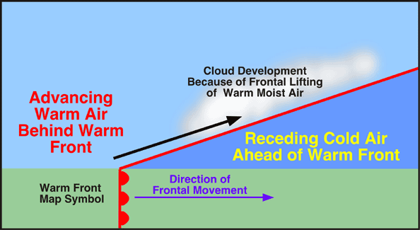
Figure 7r-3: Atmospheric cross-section of a warm front.
Occluded fronts are produced when a fast moving cold front catches and overtakes a slower moving warm front. Two types of occluded fronts are generally recognized. A cold type occluded front occurs when the air behind the front is colder than the air ahead of the front. When the air behind the front is warmer than the air ahead of the front a warm type occluded front is produced. Warm type occlusions are common on the west coast of continents and generally form when maritime polar air collides with continental polar or arctic air. The cross-section diagram in Figure 7r-4 illustrates a cold type occlusion. Note that in the occlusion process the invading mild moist air that was found behind the warm front has been lifted into the upper troposphere.

Figure 7r-4: Atmospheric cross-section of a occluded front.
Finally, the frontal systems described on this page are often associated with a storm system known as the mid-latitude cyclone. The next section will describe this weather phenomenon in detail.