The Global Precipitation
Climatology Project (GPCP)
was established by the World
Climate Research Program (WCRP)
in 1986 with the goal of providing monthly mean
precipitation data on a 2.5 x 2.5 degree latitude-longitude
grid for the period 1980-2004. The GPCP has
accomplish this by combining infrared and microwave
satellite estimates of precipitation with rain
gauge data from more than 30,000 stations. Infrared
precipitation measurements are obtained from GOES (United
States), GMS (Japan)
and Meteosat (European
Community) geostationary satellites and National
Oceanic and Atmospheric Administration (NOAA)
operational polar orbiting satellites. Microwave
estimates are obtained from the U.S. Defense
Meteorological Satellite Program (DMSP)
satellites using the Special
Sensor Microwave Imager (SSM/I).
Together these data sets will be used to validate
general circulation and climate models, study the
global hydrological cycle and diagnose the variability
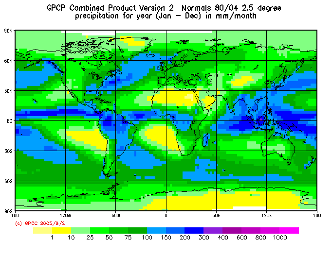
of the global climate system. Figure 8g-1 describes
mean annual global precipitation over an twenty-five
year period measured in millimeters per month.
Figure
8g-1: Mean
annual global precipitation 1980-2004. (Source:GPCC
- Visualizer).
The animation in Figure
8g-2 describes
mean monthly global precipitation determined
for the period 1980 to 2004 measured in millimeters
per month.
Figure 8g-2: Animation
showing global
mean monthly precipitation for
1980-2004. (Original source of images:GPCC
- Visualizer).
(To
view this animation your browser must have
Apple's QuickTime plug-in.
The QuickTime plug-in is available
for Macintosh and Windows operating system
computers and can be downloaded FREE from the
World Wide Web site www.apple.com/quicktime).
The average annual precipitation
of the entire surface of our planet is estimated
to be about 1050 millimeters per year or approximately
88 millimeters per month. Figures
8g-1 and 8g-2 indicate
that actual values vary spatially from less than
10 millimeters per month or to a maximum of more
than 300 millimeters per month depending on location.
The reasons for these patterns are as follows:
The deserts in the subtropical regions occur because
these areas do not contain any mechanism for lifting
air masses. In fact, these areas are dominated by
subsiding air that results from global circulation
patterns.
Continental areas tend to be dry because of their
distance from moisture sources.
Polar areas are dry because cold air cannot hold
as much moisture as warm air.
Areas near the equator achieve high rainfall amounts
because constant solar heating encourages convection,
and global circulation patterns cause northern and
southern air masses to converge here causing frontal
lifting.
Mid-latitudes experience cyclonic activity
and frontal lifting when polar and subtropical air
masses meet at the polar front. Further, the air
masses in this region generally move from West to
East, causing levels of precipitation to decrease
East of source regions.
Mountain ranges near water sources can receive
high rainfalls because of orographic
uplift, if and only if the prevailing winds
are in their favor. This can also result in a sharp
reduction in rainfall in regions adjacent or on the leeward slopes of these areas.
This phenomenon is commonly know as the rainshadow
effect.
Table 8g-1 describes some of the precipitation
extremes recorded around the world.
Table
8g-1: Precipitation
extreme weather records.
Citation: Pidwirny,
M. (2006). "Global Distribution of Precipitation". Fundamentals of Physical Geography,
2nd Edition. Date
Viewed. http://www.physicalgeography.net/fundamentals/8g.html
Created by Dr. Michael Pidwirny & Scott Jones University of British Columbia Okanagan