The Earth's continental crust consists of three discernible units, each with their own characteristics. These units are cratons, mountain belts, and continental margins.
Cratons
All of the continental masses on the Earth have a central foundation of very old basement rock. Basement rock is composed of mixtures of ancient granite, gneiss, schist, volcanic, plutonic, and sedimentary rocks. Some of the Earth's oldest rocks are found in this geologic formation. Basement rock that is exposed at the Earth's surface is called shield. The shields extend for thousands of kilometers and dip ever so slightly from a slightly elevated center. Layers of younger sedimentary strata up to 2000 meters deep cover most of the basement rock. These sedimentary deposits are sometimes called the platform of the continents. The deposits making up the platform were laid down in shallow seas in repeated episodes over the last 600 million years. The platform and the basement rock together form a craton. The continents of Australia, North America, South America, and Africa each have a single continuous craton forming their nucleus. Eurasia is composed several distinct cratons that are separated from each other by the Alps, Ural, and Himalaya mountain belts.
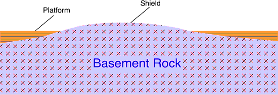
| Figure 10o-1: Cross section showing the relationship between basement rock and platform sedimentary deposits. Note that the surface of the basement rocks (the shield) is gently arched. |
The craton of North America has been relatively stable for about 600 million years. Prior to this period, the North American continent saw several periods of very active growth with the amalgamation of once distinct cratons and the addition of rock along it's margins. Geologic evidence suggests that North America is made up of several once independent minicontinents. Scientists believe that the amalgamation of these minicontinents into the core of the North America continent was complete by about 2.5 billion years ago.
On a global scale, about 70 percent of the Earth's continental crust was formed by 2.5 billion years ago. Over the next 2 billion years, the planet's continents would continue to growth through the accretion of sedimentary rock and the addition of igneous rocks along the continental margins. This growth was also driven by tectonic processes. The accretion of sedimentary rock occurred with the collision of tectonic plates which pushed ocean sediments onto the continents. Plate subduction created enough heat to melt rock into magma beneath the margins of the continents. This magma then migrated upward through the crust to form intrusive and extrusive igneous features and deposits. This process also added significant mass to the continents.
Mountain Belts
Numerous mountain belts are also found on the continents. These features are often located on the edge of cratons. Mountain belts are the result of tectonic processes that cause to crustal plates to collide. This collision results in the folding and faulting of rock, igneous intrusive and extrusive activity, and metamorphism. The elevated relief common to mountain belts is generally caused by the compression of rock into a smaller area. Uplift may also be caused by the upward migration of magma through the crust to produce granitic batholiths. Some mountains occur in isolation like Mount Rainier in the state of Washington, USA. These features are volcanic and are produced by localized extrusive igneous activity.
Continental Margin
Located between the terrestrial continents and the ocean basins is the continental margin. Two basic types of continental margin are recognized: active and passive. Active continental margins occur in the Pacific ocean. Active margins are generally narrow tectonically active areas. They are also associated with earthquakes, oceanic trenches, and volcanoes. Passive continental margins are relatively wide and have a lack of volcanic activity and few earthquakes. The continental margin is actually made up of three structures: the continental shelf, the continental slope and the continental rise. Both the continental shelf and slope are structurally part of the continents, even though they are below the sea surface.
The continental shelf is a shallow (average depth 130 meters) gently sloping part of the continental crust that borders the continents (Figure 10o-2). The extent of this feature varies from tens of meters to a maximum width of about 1300 kilometers.
Figure 10o-2: Marginal features found at the interface of the continents and the ocean basins.
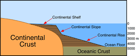
The continental slope extends from the continental shelf at an average depth of about 135 meters. The base of this steeply sloping (from 1 to 25°, average about 4°) topographic feature occurs at a depth of approximately 2000 meters, marking the edge of the continents. The width of the slope varies from 20 to 100 kilometers. The boundary between the continental slope and shelf is called the continental shelf break.
At the base of the continental slope an accumulation of sediments may develop. This accumulation of sediments is properly known as the continental rise. The continental rise is composed of a number abyssal fans that run side-by-side along the edge of the continental slope. Abyssal fans are usually associated with a deep submarine canyon cut into the continental slope. Under water abyssal fans can be compared to terrestrial landforms known as alluvial fans. The sediments that make up this feature are transported down the continental slope by turbidity currents, underwater landslides, and several different processes that move clay, silt, and sand. Most of this sediment is terrestrial in origin. The depth of the continental rise ranges from 2000 to 5000 meters deep. The continental rise can be as much as 300 kilometers wide.
Topography of the Terrestrial Surface
Figure 10o-3 classifies the Earth's terrestrial surface in to six different categories based on topography. Most of the Earth's terrestrial surface is dominated by reltively flat low and high plains. The low plains tend to be areas of sediment deposition because of their low elevation. The high plains can have elevations as high as 600 meters and are more strongly influenced by erosion. Both of these topographic features are often associated with craton's and their exposed shield and platform surfaces. Local relief on both types of plains is less than 100 meters. The three types of mountains shown in Figure 10o-3 have local relief in excess of 500 meters and slope angles greater than 5°. Many of the "low" mountains are very old structures that have been reduced in height by erosion. Plateaus have altitudes that are greater than the high plains but less than mountains. Local relief of this topographic feature varies between 100 and 500 meters. Some plateaus are the remnants of eroded mountains. Others have formed because of large-scale block faulting.
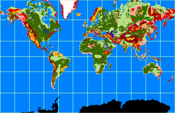
| Figure 10o-3: The Earth's various topographic regions. The legend below describes the colors associated with the six topographic regions shown. Glaciers are colored white. |