Introduction
Streams alter the Earth's landscape through the movement of water and sediment (Figure 10y-1). Streams are powerful erosive agents moving material from their bed and banks. In mountainous regions, stream erosion often produces deep channels and canyons. Streams also deposit vast amounts of sediment on the terrestrial landscape and within lakes and ocean basins.

|
Figure
10y-1: Portion
of stream channel located in the headwaters.
Steep elevation gradient makes this part
of the stream very effective at erosion and
transportation of sediment. |
Geomorphologists often view streams as systems. The stream system, like almost all environmental systems, is open to both inputs and outputs of various types of materials. Water enters the stream system by direct precipitation in the channel, from runoff, throughflow, and by groundwater flow. The movement of water into a stream also carries with it dissolved and solid materials eroded from the surrounding landscape, stream banks, and the stream bed. Sediments carried by streams to lower elevations are occasionally deposited and stored at numerous locations for various periods of time within the stream system before they reach their final resting place.
Losses of material carried by the stream system occurs through a number of processes. Water is lost by evaporation, seepage, and flooding. Streamflow ends when the water carried by stream enters a receiving basin like a lake or an ocean. Sediment is lost by various types of deposition.
The Long Profile of Streams
The topographic long profile or grade of an average stream is concave-upwards (Figure 10y-2). At their headwaters, the grade of a stream is usually steep. As streams get closer to sea-level, the angle of the grade becomes more gently sloping. Near the mouth of the stream, the grade becomes almost flat.
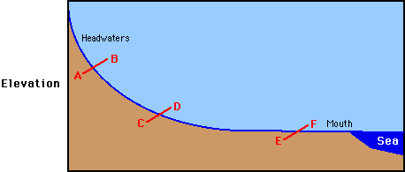
Figure 10y-2: Long profile of a typical stream.
The grade of a stream develops over thousands and sometimes millions of years. It is an equilibrium process that attempts to reduce topographic bumps in the long profile through erosion and deposition. This process is without end as crustal uplift, due to plate tectonics, is always modifying the topographic nature of the Earth's landscape.
The following diagrams and photographs illustrate the nature of the stream channel at three different locations along the stream profile. The first illustration describes the channel at point A-B (Figure 10y-3). This channel is located in the stream's headwaters. The stream gradient and surrounding topography is quite steep. Stream velocity is at a maximum and cuts a narrow deep channel. The floodplain is minimal as high velocities carry all sizes of load down stream. Stream load is high as the extreme relief provides the energy for extensive erosion producing a V-shaped river valley.
| |
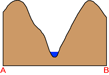 |
Figure 10y-3: Stream channel near the headwaters.
Further down the profile, changes in relief causes the nature of the stream channel to modify (Figure 10y-4: diagram C-D). The channel is now leaving the mountainous terrain and entering a landscape that is more gently sloping. This change causes a sudden reduction in the stream's velocity. The stream adjusts to this change, by depositing most of its coarse stream load onto the floodplain. The stream also takes on a braided channel form. These channels are always changing in size, number, and location because of temporal variations in stream discharge. The amount of sediment in the floodplain also varies significantly over time because of temporal fluctuations in flow.
|
|
|
|

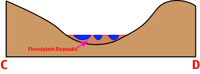
Figure 10y-4: Stream channel near the middle of a typical stream profile.
The final image and illustration describes the channel near the mouth of the stream (Figure 10y-5: diagram E-F). The extensive flat floodplain is composed of flooding deposits or point bar deposits from channel meandering. The channel is quite large and U-shaped. Stream discharge is at a maximum and sediment load is generally composed of finer materials.
|
|
|
|

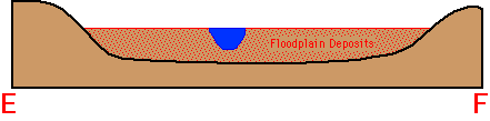
Figure 10y-5: Stream channel near the mouth of a stream.
Stream Discharge
The flow of water through a stream channel is called stream discharge. In most countries, it is measured in cubic meters per second. The following equation defines stream discharge mathematically:
Q = V x W x D
where Q is the discharge, V is the velocity, W is the average width and D is the average depth of the flow. Stream discharge varies over both time and space. Discharge normally increases downstream as more water enters the stream channel from runoff and groundwater flow. Discharge varies temporally because of chaotic behavior of its inputs like precipitation and snow melt. As discharge increases corresponding changes in velocity, channel depth and width are made within the stream system. Of the three variables that change within the stream system with an increase in discharge, velocity is the least responsive.
Velocity and Turbulence
Because of frictional drag, stream velocity is at a maximum at the center of the channel near the surface and a minimum near the bed and banks. If we examine stream velocity in three dimensions, a more complex pattern becomes apparent. The line of maximum velocity or thalweg moves from side to side within a channel.
The dynamics of stream flow is primarily influenced by friction, channel topography and channel shape. Within a stream channel, three types flow can be observed:
- Laminar flow - water flow in the stream is not altered in its direction. Water flows as parallel molecular streams.
- Turbulent flow - water flows as discrete eddies and vortices. Caused by channel topography and friction.
- Helical flow - spiral flow in a stream. Caused by channel shape. Meandering channels cause this type of flow. Helical flow has an important role in sediment transport and deposition, and in the creation of point bars.
Finally, flow is not always contained within the stream channel. During periods of high stream discharge overbank flow may occur. Overbank flow or flooding involves the spilling of water over the stream's banks and onto the floodplain.
Sediment Transport
All streams carry sediment. Most of the sediment found in a stream has been washed into the channel from surface runoff. Sediment is also added from the erosion of the stream channel bed and banks. The quantity of sediment in a stream varies temporally due to changes in discharge. Normally, as discharge and velocity increase, the amount of sediment being carried by the stream rises correspondingly.
For many discharge stations, scientists have determined the quantitative relationship between stream discharge and concentration of sediment transported by the stream. This information is often displayed graphically as a sediment rating curve. The slope of such curves tend to vary with each stream as each stream system has its own unique environmental characteristics.
During periods of low discharge, very little sediment movement takes place, and material found in the beds and banks of river channels tend to be stable. When discharge increases, more and more sediment is eroded from the stream bed and stream banks. Loose sediment on the bed is picked up as the fluid drag of the flowing water increases. High levels of discharge also causes significant amounts of material to be added to the flow of the stream from the erosion of the stream bank. This process is called bank-caving by hydrologists.
Streams generally transport three types of material: bed load (pebbles and sand which move along the stream bed without being permanently suspended in the flowing water), suspended load (silts and clays in suspension) and dissolved load (material in solution) (Figure 10y-6). The absolute quantities and the relative proportions of these types of stream load vary from one stream to another, and within a single stream from one time to another.
|
Figure 10y-6: The following animation shows some of the processes that move solid material within a stream channel. Along the stream bed particles are moved via traction (sliding and rolling) and saltation. Saltation is a process where particles moves from the stream bed to the medium in quick continuous repeated cycles. The action of returning to the surface usually has enough force to cause the entrainment of new particles. Particles that are transported as suspended load remain entrained in the flowing water for long periods of time. These particles can be deposited to the stream bed when stream velocity is reduced. (To view this animation your browser must have Apple's QuickTime plug-in. The QuickTime plug-in is available for Macintosh and Windows operating system computers and can be downloaded FREE from the World Wide Web site www.apple.com/quicktime). |
Human activity adds large amounts of dissolved and solid material to streams. These added materials include fertilizers, animal waste, and soluble compounds that are the by products of agriculture, forestry, and industry. Agriculture and forestry also add large amounts of solid sediment into streams because of their disturbance of vegetated surfaces.