Precipitation
We can define precipitation as any liquid or solid aqueous deposit that forms in a saturated atmosphere (relative humidity equals 100%) and falls from clouds to the ground surface. It is important to recognize that most clouds do not produce precipitation. In many clouds, water droplets and ice crystals are just too small to overcome the natural updrafts found in the lower atmosphere. As a result, the tiny water droplets and ice crystals remain suspended in the atmosphere until they are converted back into vapor.
Water droplets and ice crystals can only fall to the Earth's surface if they grow to a size that can overcome updrafts. Conditions for growth can develop in clouds via two different processes. In clouds with temperatures above freezing, turbulent atmospheric mixing can cause droplets to grow through the processes of collision and coalescence. One initial condition, however, must be met for this process to begin: droplet size in the cloud must be variable. This initial condition allows larger and heavier droplets to collide and coalesce with lighter smaller droplets during downdraft periods. If enough atmospheric mixing occurs the larger droplets can expand by up to 250 times and can become heavy enough to fall to the Earth's surface.
The other mechanism of precipitation development involves clouds whose temperature is below freezing. In these clouds, large ice crystals grow due to the differences in vapor pressure between ice crystals and supercooled water droplets. Vapor pressure differences between ice and supercooled water causes a net migration of water vapor from water droplets to ice crystals. The ice crystal then absorbs the water vapor, depositing it on their surface. At the same time, the loss of vapor from the water droplets causes them to shrink in size. A necessary initial requirement for this process is the presence of both condensation nuclei and deposition nuclei. While deposition nuclei form ice crystals at temperatures just below zero degrees Celsius, condensation nuclei can remain liquid (supercooled) to temperatures as low as -40° Celsius depending on size. Because of this phenomenon, cold clouds can contain both ice crystals and supercooled water droplets. The relative proportion of these two types of particles determines whether snow crystals grow to a size to overcome atmospheric updrafts.
The following list describes the various types of precipitation that can form in the atmosphere:
Rain is any liquid deposit that falls from the atmosphere to the surface and has a diameter greater than 0.5 millimeters. The maximum size of a rain drop is about 5 millimeters. Beyond this size inter-molecular cohesive forces become too weak to hold the mass of water together as a single drop.
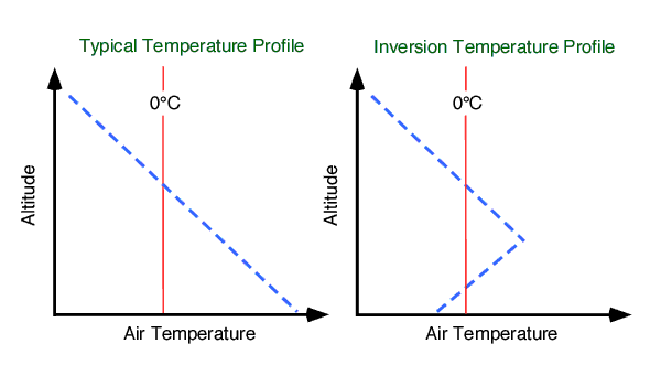
Freezing rain takes place when falling liquid water droplets encounter a surface with a temperature below 0° Celsius. Upon contact with this surface, the rain quickly turns into ice. Another inportant condition required for freezing rain is that the atmosphere where rain develops must be above freezing. A situation where warm air is found on top of cold air is called a temperature inversion (Figure 8f-1). Temperature inversions are not the common state of the lower atmosphere. Usually, air temperature descreases with an increase in altitude in the troposphere. In the mid-latitudes, we often find temperature inversions developing along the moving front edge of a cold air mass that is overtaking warmer air. This condition causes the less dense warm air to be pushed up and over the more dense cold air.
Figure 8f-1: Typical temperature profile in the troposphere compared to a situation where a temperature inversion exists.
Ice pellets or sleet are transparent or translucent spheres of frozen water. They have a diameter smaller than 5 millimeters. This form of precipitation develops first as raindrops in a relatively warm atmosphere where the temperature is above freezing. These raindrops then descend into a colder lower layer of the atmopshere where freezing temperatures occur. In this layer, the cold temperatures cause the raindrops to freeze into ice pellets during their transit to the ground surface. Similar to freezing rain, an air temperature inversion is required for the formation of ice pellets.
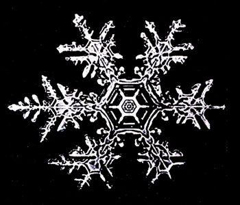
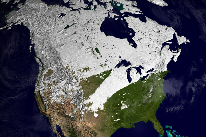
Snow is a type of precipitation common to the mid and high latitudes (Figure 8f-2). Snow develops when water vapor deposits itself (skipping the liquid phase) directly on a six-sided (hexagon) deposition nuclei as a solid crystals, at temperatures below freezing. The unique form of snowflakes occurs because ice crystal growth is most rapid at the six points associated with geometric shape of the deposition nuclei. These points are more directly exposed to the atmosphere and consequently convert more water vapor into ice. Snow is usually generated by frontal lifting associated with mid-latitude cyclones. Snowfall can occur in the fall, winter, and spring months when atmospheric temperatures can drop below freezing. Much of the ground surface of North America can be covered with snow for several months during a typical year (Figure 8f-3).
Figure 8f-2: Close-up photograph of a snowflake. (Source: NOAA Photo Collection Website).
Figure 8f-3: Extent of North American ground snow coverage, Feburary 2-9, 2002. (Source: MODIS Snow/Ice Global Mapping Project).
Snow pellets or graupel are spherical white bits of ice that have a diameter less than 5 millimeters. Snow pellets develop when supercooled droplets freeze onto the surface of falling snowflakes. Snow pellets usually fall for only a brief period of time when a precipitation event changes from ice pellets to snow.
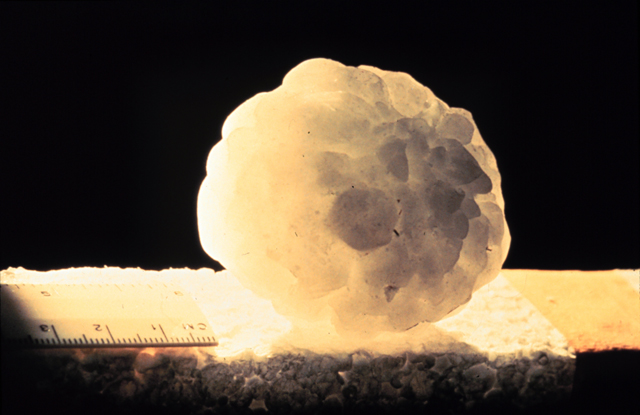
Hail is a type of frozen precipitation that is more than 5 millimeters in diameter (Figure 8f-4). Hailstones often have concentric shells of ice alternating between those with a white cloudy appearance and those that are clear. The cloudy white shells contain partially melted snowflakes that freeze onto the surface of the growing hailstone. The clear shells develop when liquid water freezes to the hailstone surface. Strong updrafts in mature thunderstorm clouds provide the mechanism for hail formation. These updrafts move hailstone embryos (often large frozen raindrops) upward through the storm cloud where they encounter layers of ice crystals, snow, and supercooled rain (Figure 8f-5). Each encounter causes the hailstone to grow larger in size as ice, snow, and rain accretes to the surface. Hailstones can grow very large in size when they are carried upward by more than one updraft. When the hailstone becomes too heavy to be supported by updrafts, it begins falling under the influence of gravity. Descending hailstones can lose a significant amount of their mass because of melting as they encounter the warm air found in between the cloud base and the Earth's surface. Small hailstones often melt completely before they reach the ground.
Figure 8f-4: Hailstone measuring 21 centimeters in circumference. (Source: NOAA Photo Collection Website).
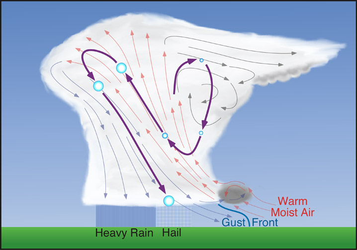
| Figure 8f-5: Typical hailstone growth path through a thundersorm cloud. Hailstones add most of their mass during updrafts. |
Fog
Fog is simply a cloud of minute water droplets that exists at gound level. Fog develops when the air at ground level is cooled enough to cause saturation (relative humidity equals 100%). Meteorologist have a very specific definition to determine if fog exists. This definition suggests that fog is occurring when the visibility of the atmosphere, near the Earth's surface, becomes less than 1 kilometer. Fog can be created by a variety of processes:
Radiation fog or ground fog, is produced by near surface cooling of the atmosphere due to longwave radiation emission. This particular type of fog is normally quite shallow and develops during the evening hours. Shortly after sunrise the radiation fog disappears because of surface heating due to the absorption of solar radiation.
Upslope fog is created when air flows over higher topography. When the air is forced to rise in altitude because of the topographic barrier, it is cooled by adiabatic expansion. This type of fog is often found forming on the windward slopes of hills or mountains.
Advection fog is generated when air flows over a surface with a different temperature. Warm air advection can produce fog if it flows over a cold surface. The contact cooling associated with this process causes satuation to occur in a relatively thin layer of air immediately above the ground surface.
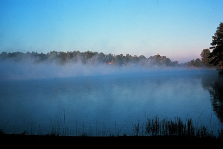
Evaporation fog is a specific type of advection fog. It occurs when you get cold air advancing over warm water or warm, moist land surfaces. In this situation, fog forms as water from the surface evaporates into the cold air and then saturates (Figure 8f-6). This type of fog can also be called steam fog or sea smoke.
Figure 8f-6: Evaportation fog forming over a lake as cool air flows over the warm water. (Source: NOAA Photo Collection Website).
Frontal fog is a type of fog that is associated with weather fronts, particularly warm fronts. In this situaton, rain descending into the colder air ahead of the warm front can increase the quantity of water vapor in this atmosphere through evaporation. Fog then forms when the quanity of water in the atmosphere ahead of the front reaches saturation (relative humidity equals 100%).